
Image public


Nowadays, geodata are becoming more and more dominant in many workflows. Moreover, with new advanced acquisition techniques such as LIDAR or Photogrammetry, the emergence of massive 3D/4D data are, somehow, an issue for sharing and vizualizing such kind of geoassets.
The main objective of this task is to gather in a unique web application 2D, 3D and 4D geodata (and their associated metadata), in order to find, share and visualize all the geo assets of a company.
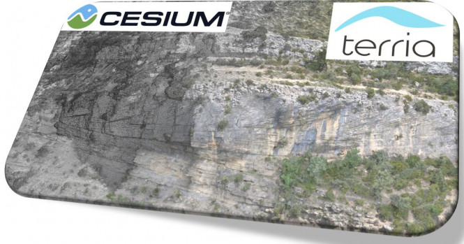
The demo project is built on CesiumJS, a javascript open sourced framework dedicated on fast and smooth 3D/4D geodata.
Also, another framework has been evaluated, TerriaJS. It is more complete framework build on Cesium with a fonctionnal user interface (build on React).
Several types of geodata have been put in these frameworks: BIM (Building Information Model), DOM (Digital Outcrop Models), GIS geodata (shapefile, geosjson, geotiff/geojpg) and so on. The visualization is, as expected very fast and smooth. For ex. a DOM weighing 6 Go, is not an issue for such technologies.
The CesiumJS and TerriaJS frameworks could be used to develop a web platform to find, share, visualize geodata. Also, we could think to develop a tailored-made front-end and create data transformation API to be able to load as many types of geodata as possible.
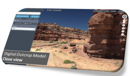
Fast and smooth visualization
The tiled and the Level of Detail (LOD) data format (included in The CesiumJS framework) allow to ease the visualization of massive 3D geodata.
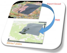
Data Flow Example
CesiumJS (and TerriaJS) are using specific, open-sourced, data format for 3D vizualisation. Even though Cesium has built a commercial web platform to perform ETL (Extract Transform Load) operations (CesiumION), nowadays open-source tools are already available to operate nice data flow.

Check out all benefits of TELLUS Share membership
Digital transformation
towards geosciences 4.0
