
Image public


In geoscience many data are represented in the form of maps. Maps can be at various scales, the size of study domain, region, country or global. Maps are also often the result of quantitative or qualitative research or evaluation study. Maps are very effective in geoscience to synthetize or aggregate various results or data spatially.
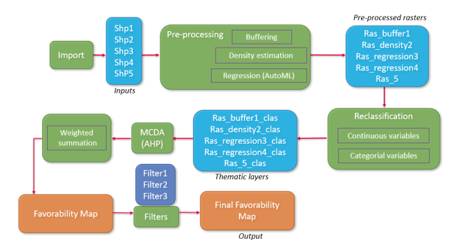
Map construction involves creating, visualizing, and analyzing maps through interpolation, extrapolation, and regression. Highly multivariate and non-linear statistical correlations can be captured with Machine Learning techniques, and combined with more classical geostatistical methods to include spatial autocorrelation, geological knowledge and further calibration to well data. A comprehensive workflow is essential for managing the multi-step process of producing maps efficiently.
Datamix is a Python library designed for geoscience map operations, offering tools for building, displaying, and analyzing data maps, as well as performing geometric calculations and multi-criteria decision analysis such as AHP (Analytic Hierarchy Process). It also features a workflow system for automating map-building steps, enabling probabilistic predictions from stochastic analyses.
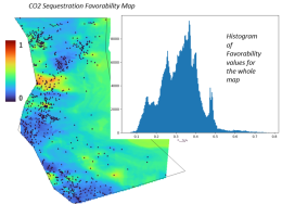
The Datamix package, developed in the Tellus project, has been applied to evaluate the geothermal potential of British Columbia using the AHP method. This involved creating a prospectivity map by combining criteria maps, such as heat flow, faults, volcanoes, and hot springs, with expert assessments based on geological domains. The package was also used to assess CO2 storage potential in the Balder Formation of the Norwegian North Sea. This study involved constructing a porosity map using machine learning and applying the AHP method to evaluate criteria such as porosity, burial, thickness, fault distance, and net-to-gross ratios.
The workflow demonstrated in the two use cases is adaptable for creating various types of prospectivity maps with different datasets. The Datamix package is versatile for other geoscience applications and can be expanded with newly developed methods to enhance its functionality.
Favorability from AHP method
In a CCS exploration study, a regional favorability map can be obtained by aggregating multiple attributes about the target geological formation, such as Thickness, Porosity, Burial, Distance to faults and Net-to-Gross, with relative weights provided by an expert and processed through the AHP method.
Results & Uncertainty
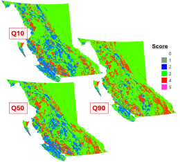
The prospectivity map can be evaluated and constructed by accounting input data uncertainty. The principle is to evaluate the uncertainty degree and range of each input data. The map calculation is totally automatic once the input data has been provided and the expert opinion has been supplied. Then a Monte-Carlo procedure can be conducted to produce stochastic simulations. Next the images map for each random sample are generated and corresponding Q10 Q50 & Q90 maps are built.

Check out all benefits of TELLUS Share membership
Digital transformation
towards geosciences 4.0
